Tags: DJI Wookong
| Quantity | 3+ units | 10+ units | 30+ units | 50+ units | More |
|---|---|---|---|---|---|
| Price /Unit | $2,283.72 | $2,237.12 | $2,167.21 | $2,073.99 | Contact US |
 WIFI V2.0 Pixhawk 2.4.8 Flight Controller w/ I2C Expansion Board + PPM Encoder + RGB LED Indicator
$150.12
WIFI V2.0 Pixhawk 2.4.8 Flight Controller w/ I2C Expansion Board + PPM Encoder + RGB LED Indicator
$150.12
 WIFI V3.0 Pixhawk 2.4.8 Flight Controller w/ I2C Expansion Board + PPM Encoder + RGB LED Indicator
$156.37
WIFI V3.0 Pixhawk 2.4.8 Flight Controller w/ I2C Expansion Board + PPM Encoder + RGB LED Indicator
$156.37
 GEPRC GEP-F405-HD V2 Flight Controller Plug and Play STM32F405 Chip ICM42688-P Gyroscope for DJI Air Unit
$32.08
GEPRC GEP-F405-HD V2 Flight Controller Plug and Play STM32F405 Chip ICM42688-P Gyroscope for DJI Air Unit
$32.08
DJI Wookong M Waypoint (5 points)+ Data Link 900Mhz + Wookong M Autopilot System
Description:
WooKong-M Specialized Station Of Multirotor autopilot systems for WKM Waypoint
- The Wongkong-M Waypoint Ground Station is the upgraded version of the Wongkong-M Single Waypoint Ground Station. It improves the function of way point editing for the ground control station. The line of DJI waypoint products provides waypoint mode, F channel controller, general purpose servo action, and 6 route templates. The maximum way points that could be added are twenty. It also supports the changing and editing of the flight route before or during the fight.
Reliable Datalink for ACE Single Waypoint,ACE Waypoint,WKM Single Waypoint,WKM Waypoint
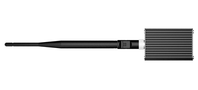
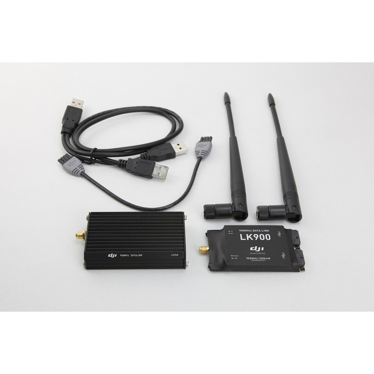
- DJI offers 2.4Ghz and 900MHz datalink to achieve long-range two-way communication. The datalink maximum distance is up to 15km. The ground end also link with USB power supply that is convenient for outdoor using. The wireless module uses FHSS technology which is verified by FCC and CE certification, DJI datalink has many advantages such as: high data rate, stable performance, strong anti-interference capability, and long communication distance. The 2.4GHz datalink’s power consumption is 550mw and 900MHz datalink 1.5W, which is big advantage for long-distance flight mission.
Industrial Flight Control Algorithm for ACE Single Waypoint,ACE Waypoint,WKM Single Waypoint,WKM Waypoint
- The entire Ace Waypoint system combines GPS 6DOF inertial measurement unit, magnetometer, pressure altimeter sensors to optimize robustness of algorithms and robotic control logics. Ace Waypoint system utilizes advance GPS/INS proprietary algorithm technology in the entire design. Even in adverse condition, high vibration and high demand environment, the helicopter maintains flight stability accurately to ensure mission success rate.
Quick GPS Acquisition / Simple Compass Calibration for ACE Single Waypoint,ACE Waypoint,WKM Single Waypoint,WKM Waypoint
- System design and use of high grade components enables fast GPS acquisition time. Compass calibration with 45° tolerance is easier and faster than previous model.
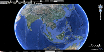
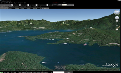
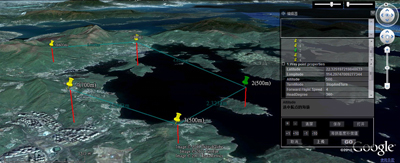
Google 3D Map for ACE Single Waypoint,ACE Waypoint,WKM Single Waypoint,WKM Waypoint
- Ace Waypoint designed around intuitive Google 3D map offering GIS data. Pilot can operate and plan flight routes anywhere, use PC mouse to zoom in/out of 3D Maps which can be downloaded to PC and used else way in offline mode.
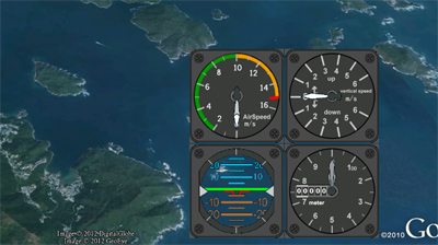
Real-time flight Monitoring for ACE Single Waypoint,ACE Waypoint,WKM Single Waypoint,WKM Waypoint
- In addition to the helicopter location, heading and altitude, our ground station also provides other flight data such as attitude, air speed, vertical speed, throttle and pitch percentage and servo voltage at all times.
Failsafe Auto Returning/ One Key Go Home for WKM Single Waypoint,WKM Waypoint
Ground Station equipped with intelligent adaptive system.
- During abnormal signal lose , the system will adjust to environment to activate failsafe appropriately. The aircraft will implement the mission and complete the default route mission automatically, even when datalink signal lost.
- When user use manual mode, the aircraft will keep hover when RC signal lost. But after 10S, if the signal didn’t come back, the aircraft will find the take-off point precisely and come back to take-off point with safest route and height . Then the aircraft will hovering over the take-off point automatically after its activate point. This function offers the intelligent security protection for user’s expensive aerial equipment. In addition, the user can always click the return button, the system will interrupt the current mission immediately to order the aircraft to back the take off point .
Keyboard/ Joystick Mode for ACE Single Waypoint,ACE Waypoint,WKM Single Waypoint,WKM Waypoint
- Operator can either use keyboard or joystick with ground station system to control the helicopter movements and attitude via DJI data link. Manual mode can be applied when out of radio (transmitter) signal range by using either keyboard or joystick for control. This provision/feature allows control when the radio (transmitter) stopped working after mission started.
- Click on any point on a 3D map, aircraft can achieve the coordinates point automatically, particularly suited to some routes cannot be set in advance. Flight altitude and flight speed can also be adjusted rapidly and accurately according the change of data and waypoints when user have to change the target and flight mission.
- DJI emphases the principle of user friendliness in all designs, the ground station offers 3D graphic interface, a breakthrough from traditional UAV system with ease of installation, less complexity and ease of operation in comparison to others in the market. DJI ground station control can save time, improve operation efficiency, ease mission planning supporting flexible and intelligent way for any mission.
BVR automatic flight for ACE Waypoint,WKM Waypoint
- Beyond Visual Range (BVR) of Ground Stations System designed for high-ending commercial and industrial automatic flight that rely on a reliable long-range wireless communication device (Data Link) and ground station control system (GCS). The flight route, default action of photographs, airdrop can be planned in advance on the ground station control software.
Auto Takeoff/ Landing for WKM Waypoint
- Waypoint controller advance development offers automatic take off and landing feature which can be applied using either by radio transmitter or ground station keyboard. Take off and landing (ascending and descending) speed is 0.2 to 0.5 meter per second.
20 defined waypoints for WKM Waypoint
- Way point is the basic element for flight mission. The maximum way points that could be added are 20 which meets the requirements of ordinary flight mission. Users can set the altitude, latitude, longitude, speed, heading angle, the turn mode and the length of time for hovering for each way point. Users can also do it for all the way points at one time.
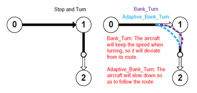
3 waypoint turning mode options for ACE Waypoint,WKM Waypoint
- There are 3 different fight routing planning mode: fixed-point turn mode, coordinated turn mode and adaptive coordinated turn mode.
- Fixed-point Mode: Aircraft fly to the first fixed point accurately, then stay at the fixed point and then fly to the next fixed point . The fixed points and the length of staying also can be set in advance.
- Coordinated turning mode: The route of aircraft would be smart to be calculated with turning speed and turning angle. The helicopter would fly from one point to another point without stop.
- Adaptive coordinated turning mode: It is almost the same performance with Coordinated Turning mode. But the flight routine will be more accurately with the planned flight routine in this mode.
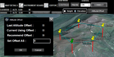
2 Waypoints Altitude Display Mode for ACE Waypoint,WKM Waypoint
- Real time flight altitude data is vital in real time flight data collection. Correct Ace Waypoint altitude setting determines the success of the flight mission. There are two displays for height; normal height and elevated mode. In normal height mode, the system records the helicopter at 0 height reference point- above (+) value means above ground and (-) value means below ground. In elevated mode, the helicopter altitude is the same as elevation according to Google Map. Due to altitude sensor can be affected by weather condition, an offset of altitude is necessary. Please refer to manual for detail setup.
Custom Servo Channel Control for ACE Waypoint,WKM Waypoint
- Ace One and Ace Waypoint provide two servo outputs to support custom servo feature. These two outputs can be used between the controller and or 3rd party devices. These outputs for example can be used for camera shutter operation, air-drop activation or other switching devices.
Batch route task setting for ACE Waypoint,WKM Waypoint
- During a flight mission, task start, delay and repetitive time can be set. By setting the time period, repeat time, start delay and repeat time parameters; operator can customize these function to a specific application
Editing Real-time flight route momentarily for ACE Waypoint,WKM Waypoint
- During flight mission, operator can re-edit mission such as modifying flight routes, or waypoints to achieve a real-time adjustment to complete the objectives. Operator can also click “Pause” button to suspend the mission; helicopter will slow down and hover awaiting new assignment. When and if signal is lost, the system will intelligently pick the optimal route to return home automatically.
F channel controller for ACE Waypoint,WKM Waypoint
- User also can custom main controller’s F1 to F4 channel ‘ s output signal to achieve the extra device operation such as Servo, Gimbal and Camera controlling.
Using Relative Coordinates Editor for ACE Waypoint,WKM Waypoint
- Relative coordinates Editor is an accurate drawing tool of regular geometric figures on 3D Map. Operator can set an initial waypoint then next waypoint with angle and distance. Ace Waypoint system will calculate the next waypoint coordinates accurately.
Simulation for ACE Waypoint,WKM Waypoint
- Ace Waypoint system can simulate real flight environment, operator does not have to perform actual flight to complete mission in simulated mode. The simulation mode is good for training and mission test.
Upload/download flight mission for ACE Waypoint,WKM Waypoint
- All routes/waypoint settings can be exported and saved from the controller to any computer (PC). The saved files can be imported for future use.
+ Data Link 900Mhz + Wookong M Autopilot System")
+ Data Link 900Mhz + Wookong M Autopilot System")
+ Data Link 900Mhz + Wookong M Autopilot System")
+ Data Link 900Mhz + Wookong M Autopilot System")
+ Data Link 900Mhz + Wookong M Autopilot System")
+ Data Link 900Mhz + Wookong M Autopilot System")
+ Data Link 900Mhz + Wookong M Autopilot System")
+ Data Link 900Mhz + Wookong M Autopilot System")
+ Data Link 900Mhz + Wookong M Autopilot System")
+ Data Link 900Mhz + Wookong M Autopilot System")
+ Data Link 900Mhz + Wookong M Autopilot System")
+ Data Link 900Mhz + Wookong M Autopilot System")


