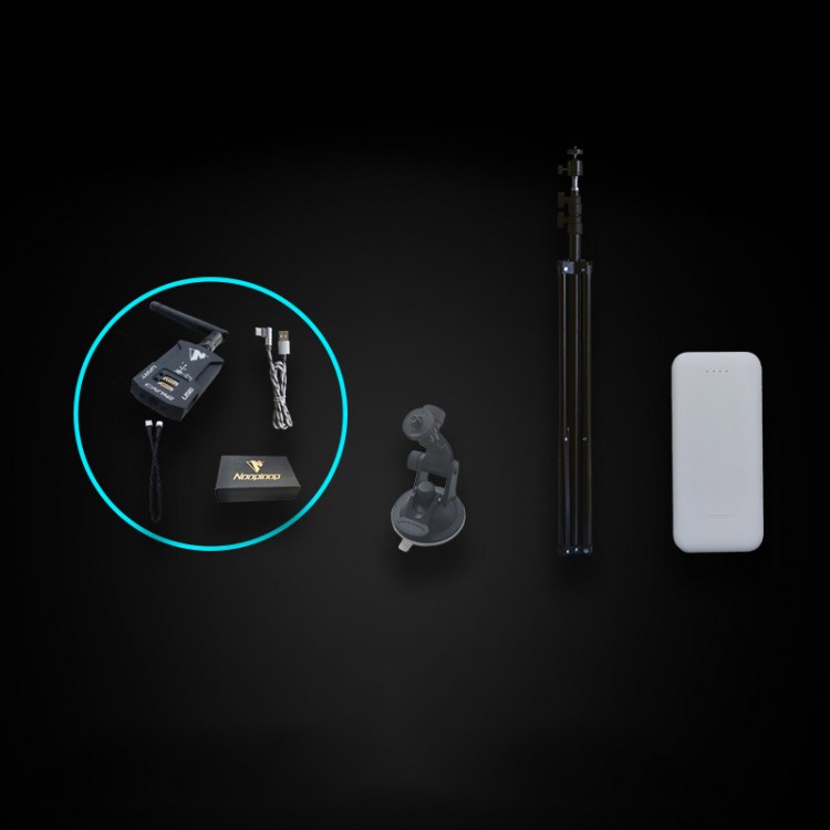
UWB Positioning Indoor Distance Sensor Module 500m Communication Distance LinkTrack P Ready To Use Kit
Package Included:- 6 x LinkTrack P Modules
- 6 x GH1.25 4P Adapter Cables
- 6 x USB Type-C Data Cables
- 6 x Suction Cups
- 4 x Tripods
- 4 x 20000mAh Power Banks
How to Choose LinkTrack UWB Positioning System?1. Familiar with the product: Users
need to read product manual and visit the link
www.nooploop.com to be
familiar with the product. Learn about the various LinkTrack models in
advance. The same hardware supports three running modes LP, DR, and DT,
and supports basic features such as tag, base station, and console
roles.
2. Usage Scenarios:Clarify the application scenarios and operating modes that need to be used.
If
you need to achieve single-zone positioning (such as a single room,
stadium, football field, etc.), use LP Mode. Generally, the minimum
positioning system contains 4 base stations, and the number of tags is
the same as the object to be located. At the same time, 1 console can be
added to release more Multifunction.
If you need to achieve
mutual distance measurement between 3 points: use DR Mode and purchase 3
LinkTrack modules. If you only need to achieve two-way digital
communication between two modules: you can use DT Mode and purchase two
LinkTrack modules.
3. Choose Models:Model selection mainly considers communication distance, communication frequency band, size and weight.
Communication
Distance: The distance of each model may be different. For scenarios
with high reliability requirements, it is generally recommended to use a
distance not exceeding half of the communication distance. For example,
for a single area positioning scenario with 4 base stations in LP Mode,
using the diagonal as the distance calculation, LTS is recommended to
be used within 25*25 meters, LTP is recommended to be used within
200*200 meters, and LTPS is recommended to be used within 120*120
meters.
Communication Frequency Band: LTS and LTSS communication
frequency bands are the same, LTP and LTPS communication frequency
bands are the same, so in general, LTS and LTSS can be mixed, LTP and
LTPS can be mixed, LTS/LTSS and LTP/LTPS are generally not mixed (please
comply with local radio regulations).
Size and Weight: LTS/LTP
are equipped with a shell, which is easy to install, protects the
circuit, and is more beautiful and generous. LTS S/LTPS is a simplified
version, which is more suitable for integration. For example, for an
application that needs to fly in formation of 8 UAVs within a range of
10*10 meters, the load of the UAV is 10g. At this time, 8 LTSS can be
selected for the tag, and 4 LTS can be selected for the base station for
easy installation, and 1 LTS or LTSS can be selected for the console.
4. Ready to Use Kit:The
ready-to-use kit is mainly used for new customers to get started
quickly. It includes 6 LinkTrack single module versions, 6 suction cups,
4 tripods, and 4 power banks, which can facilitate users to build
common scenarios for verification. If the user needs to increase the
number of tags, base stations, etc. in the later period, just add the
corresponding modules. Through NAssistant configuration, it can be
configured as "4 base stations + 2 tags" and "4 base stations + 1 tag + 1
console" when running in LP Mode. In DR Mode, 6 nodes can be configured
to measure and communicate with each other at the same time. In DT
Mode, it can be configured as "1 master + 5 slaves" mutual digital
communication and other collocations.
Description:LinkTrack
is a UWB high-precision positioning system. Through multiple core
technologies such as high-precision wireless synchronization and
wireless positioning algorithms, the positioning accuracy is higher, the
operation is more reliable, and the experience is better. Through
continuous innovation, we are committed to providing high-precision,
high-reliability, and high-experience positioning solutions for the
industry.
LinkTrack supports three operating modes: LP (local
positioning), DR (distributed ranging), and DT (digital transmission) to
meet the needs of users in more scenarios. The typical positioning
accuracy is up to 10cm, the refresh frequency is up to 200Hz, and it
supports PNTC (positioning, navigation, timing, and communication in
one), making it possible to communicate while positioning. Support
one-key calibration, wireless settings, one-key over-the-air upgrade and
other functions; at the same time, it is free to authorize the use of
multi-function NAssistant PC assistant, which can run on three major
operating systems, supports data, waveform, 2D, 3D display, data
recording, playback, and export And other functions, greatly reducing
the user's threshold for use, making the operation easier and the
development efficiency higher.
Features:LP Mode (Local Positioning Mode):LP
Mode supports simultaneous work of positioning, navigation, timing and
communication. The roles are divided into tags, base stations, and
consoles.
After the tag measures the distance to the base station
and calculates the coordinates, it is output in real time through the
communication interface, and the navigation function can be realized
after being connected to carriers such as robots and drones. The base
station and console simultaneously output all tag positioning
information in real time, and the access terminal display platform
realizes the positioning (detection) function. While positioning, the
tag and the base station/console support two-way digital communication
to realize the communication function. Each label output contains the
unified system time to realize the synchronization timing function.
The
typical 1D, 2D positioning accuracy is 10cm, and the typical 3D
positioning accuracy is 30cm. When the positioning frequency is 200Hz,
the delay is only 5ms; the base station has a capacity of up to 120, and
the tag capacity is opened by default 40, and more applications need to
be opened.
DR Mode (Distributed Ranging Mode):DR Mode
supports the integration of ranging, timing, and communication, with
only one role as a node. Each node measures the distance to other nodes
in real time, and receives data transmitted from other nodes. At the
same time, it can also transmit its own data to other nodes through the
communication interface to realize ranging and communication functions.
The output data content of each node includes a unified system time to
realize the synchronization timing function.
The typical ranging
accuracy is 10cm, and when the refresh frequency is as high as 200Hz,
the delay is only 5ms. Under 10Hz output, the node capacity is up to 50.
DT Mode (Data Transmission Mode):DT
Mode supports three sub-modes: intelligent communication, two-way
communication, and broadcast communication. There are master and slave
roles in this mode.
High-speed, low-latency wireless data
transmission can be achieved in DT Mode. The data transmission bandwidth
is up to 3Mbps, and the delay is less than 0.5ms.
One Key Calibration:For
a single area (4 base stations) scenario, after installing the base
station, you only need to send a trigger command to any base station or
console (which can be operated through NAssistant). Within 30 seconds,
the base stations will automatically measure each other's distance and
construct the base station coordinates. System and complete the base
station coordinate calibration. One-key calibration makes it possible to
build a high-precision positioning system within 10 minutes, greatly
reducing the installation time and investment cost under traditional
manual measurement calibration.
Wireless Operation:Connect
to any base station/console (connect any node in DR Mode) to pass all
the LinkTrack nodes in the NAssistant wireless operating system, so as
to realize the functions of parameter setting, restart, firmware update
and other roles of the base station, tag, console, etc.
In
industrial applications, the construction environment is often harsh and
the construction cost is high. For example, the base station is
installed on the ceiling and other places that are difficult to
disassemble. The wireless operation makes on-site installation and
debugging, system maintenance, and function upgrades more convenient,
which greatly reduces customers' later investment costs.
Fake GPS:In
LP Mode, the tag data output format supports configuration to be output
in NMEA-0183 format commonly used with GNSS (GPS, Beidou, etc.), so
that users can still obtain simulated GPS positioning through the
LinkTrack system under indoor, building shelter, and bad weather
environments. information.
Easy to Install: It is easy to put up.
NAssistant Host Computer Assistant:* Numerical display: support raw data, numerical data display, check node online status and other functions.
* Waveform display: Support multiple waveforms simultaneously display, zoom, color configuration and other functions.
*
2D display: Supports simultaneous display of multiple points and
multiple tracks, background map import, zoom, color configuration and
other functions.
* 3D display: support multi-point and multi-track
simultaneous display, posture display, zoom, color configuration and
other functions.
* Multi-window display: Supports simultaneous
display of multiple windows, multiple forms of representation in the
same state, and richer content.
* Multi-platform support: Support three operating system platforms: For Windows, Ubuntu, and MacOS.
*
More functions: support functions such as data recording, playback,
export, product settings, wireless settings, software upgrades, firmware
updates, log output, and getting started guides.
Information & Support:* Manual documents: provide detailed data manuals, user manuals, communication protocol manuals and other documents.
* NAssistant assistant software: Rich and powerful functions, multi-platform support make development more effective.
* Driver code: Provide standard C language analysis code to facilitate your transplantation to various development platforms.
* ROS support: Provide ROS driver package to reduce development cost based on ROS platform.
Applications:- Group formation: drone formation performance, unmanned fleet array, multi-robot simulation battle, etc.
- Navigation and positioning: robots, unmanned vehicles, drones and other carriers navigation and positioning
- Track capture: athlete track detection, automatic follow-up lights, etc.
- Distance measurement and obstacle avoidance: anti-collision of forklifts, cranes, port trucks, etc.
- Interactive scenes: multi-person interactive scene positioning such as VR and AR
-
Research tools: Autonomous driving simulation laboratory, indoor
high-precision motion capture system, efficient navigation and
positioning algorithm research course, etc.
 Note:
Note:
-
Some parameters are related to the use environment conditions. For
detailed parameter information, please refer to the latest official
version of data manual.
- LTSS and LTPS are schematic diagrams of
product 3D models, and the colors of the modules actually shipped are
different. Please make sure that you don't mind before purchasing.
 Black 3D-Printed Mini ESP32 Marauder Development Board Positioning Module with 1.44-inch Screen
$33.36
Black 3D-Printed Mini ESP32 Marauder Development Board Positioning Module with 1.44-inch Screen
$33.36
 White 3D-Printed Mini ESP32 Marauder Development Board Positioning Module with 1.44-inch Screen
$33.36
White 3D-Printed Mini ESP32 Marauder Development Board Positioning Module with 1.44-inch Screen
$33.36
 Black Shell T-Embed-CC1101 Plus ESP32-S3 Development Board NRF24L01 2.4GHz ISM Transceiver with 1.9-inch LCD
$88.55
Black Shell T-Embed-CC1101 Plus ESP32-S3 Development Board NRF24L01 2.4GHz ISM Transceiver with 1.9-inch LCD
$88.55


")
")
